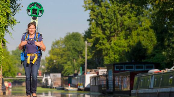
Initiated by the UK Canal and Rivers Trust, Google have offered up one of their rare Trekker Street View backpacks to the Trust's members.
Weighing 40lbs, the four-foot tall backpack houses a 360-degree camera and lets a person carry out on foot what Google's Street View vans do on roads, allowing for otherwise-inaccessible areas to be mapped. It's the first time one has been used in the UK, having previously been used to map locations like the Grand Canyon.
 |
| Genuine pic, from www.techradar.com |
"We're delighted to be the first people in the UK to get the Trekker on our backs - it's fantastic that our 200-year old network is being given a different lease of life thanks to cutting edge, 21st-century technology," said Wendy Hawk, corporate partnerships manager of the Canal & River Trust.
"The footage we get will allow millions of people from all over the world to see our canals, rivers and towpaths, and will hopefully encourage some people to make a trip to see them."
Google's Pascale Milite added: "We hope to help boost the discovery of and make these historical canals accessible to more people in the UK and across the world through Street View technology." Google and the Trust are hoping to map 100 miles of canals and waterways, kicking off at London's Regents Canal later this week. - See more here and more including a pic here.
What I find amusing is that a few years ago there was a spoof photo of a narrow boat in the cut with a Google camera on the roof. And now (truth is stranger than fiction etc) the spoof has come to pass!
 |
| (spoof pic!) |
But I suppose the serious question is - presuming the Trekker pack will be carried by a walker rather than a boater (could they hitch a ride?) - whether the view from the river is better or worse, more or less useful, than the view from the towpath. And hands up if you'd like Google to pay you for visiting your favourite canals with a camera on the roof of your boat! Count me in: I'd even quit my present job to be a Google employee afloat. Google, can you hear me?


