Showing posts with label railway. Show all posts

Saturday, 13 May 2017

The Cromford Canal

John and Sarah have been staying next to the Cromford Canal in Derbyshire, another canal now cut off from the main network and therefore inaccessible to Patience.  It was built between 1789 and 1794 by William Jessop and Benjamin Outram to provide a 14.5 mile link between the Erewash Canal and Cromford Wharf, near Richard Arkwright's historic cotton mills. The canal closed for commercial traffic in 1944, but a restored section remains open for a few miles south of Cromford, and on which a horse drawn boat operates as a tourist attraction.
Cromford Wharf
At High Peak Junction, a mile south of the canal terminus at Cromford Wharf, there was an interchange with the Cromford and High Peak Railway, which ran over the Peak District to connect with the Peak Forest Canal at Whaley Bridge, providing a short cut for the shipment of minerals and other goods, thus avoiding a much longer journey via the Trent and Mersey Canal.
High Peak Junction from where the Cromford and Hgh Peak Railway ran behind the buildings
Completed in 1831, the Cromford and High Peak Railway was engineered on similar principles to a canal and comprised a series of relatively level sections connected by very steep inclines (analogous to the locks on a canal), up which wagons were drawn by cables powered by stationary steam engines.
Railway wagon at the top of the Middleton incline
The gradients of the inclines ranged from 1 in 16 to 1 in 8 and it reached 1,266 ft above sea level, the highest point reached by a standard gauge railway in England.  It was in operation carrying freight until 1967 and part of its route now forms the High Peak walking trail.

Wednesday, 10 February 2016

Railway Stations near Canals

Canals and rivers wend their way erratically across the country, not always reaching places that are convenient to access. Here is a solution - a map and a list of Railway Stations near canals.
We have found ourselves wanting to moor up in a pleasant spot but having no easy way of getting home or even of visiting a nearby town (though Ely, see pic, is an exception).

I used Google Earth to trace the canals we planned to visit, noting railway stations up to a mile or so away from where we might moor up. We could then take the train home for a few days or visit nearby towns for a change of scene. There are 2552 stations on the Network Rail network and I've identified 290 near canals and rivers in England and Wales.
I think Google Earth is magic. There are umpteen "layers" that sit on top of the satellite images and I was thrilled to find there is a layer showing canals and rivers. So I decided to create my own layer of "railways near canals." I'll explain here how to use it, and I hope you find it useful. It's certainly a work in progress, as for many areas I have no knowledge of the ground, so I rely on you to update me and correct my data for the benefit of all.
How to set up.
Open Google Earth, or download it from here.
Now download the file  "UK_Canals_Route_Only.kmz". Click on the three vertical dots on the right in the red header and select "Download kml".  


Now import the file into your Google Earth sidebar:
(Menu: Open > and find where you saved your download)


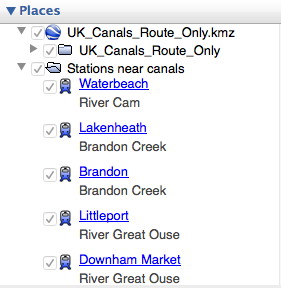
Make sure it appears in your Layers sidebar and that it is ticked. Ticked layers are visible on the map, unticked layers are not. Untick anything you don't want to give more clarity leaving those you do want to see.
Now download the file "Stations_near_canals.kmz" in the same as you did for UK Canals Route, above.
Check that this appears in your Layers sidebar and tick it if necessary. Clicking on the little triangle to the left alternately opens the list up or closes it.
 For clarity you may decide to switch off certain features such as 3D buildings, weather etc.
The selection for rail and waterways, already built in to Google Earth, is hidden in the "More" section (Layers > Primary Database > More) so open the lists by clicking on the triangle and ensure that both Rail and Waterway are ticked.
This clip shows the town of Rugby with a red dot, the railway-station-near-a-canal with a chunky blue train, a primary waterway in blue, a secondary waterway in bright green and the surrounding countryside in dark green. If you search for Rugby or click on the Rugby label in your Google Earth Places list you should see this and more!

Get Started. Now you have all the information you need to find railway stations near canals. Just browse the map using the tools at top right to zoom in and out and use your mouse to drag a route across the map.

Click on the chunky train icon to find out which canal is just a mile or so away and to get directions to and from that station.
Click on the red railway sign
to find out more about the line the railway is on and its destinations.

One other thing. The "Stations_near_canals.kmz" file can also be shown in a spreadsheet - stations_near_canals-data.xls . This shows just the unique name of the station and the nearby canal and you can search or arrange according to your needs. So you can now have a list of the nearby stations (usually within walking distance of a mile or so) for your chosen canal. Search for, or click on, the station name in Google Earth and you fly directly to it on the map, where more information can be found. 

Caution: I can't guarantee the 100% accuracy of this data. Some of it is simple rule of thumb. What seems on the map to be just a hop and a skip away could mean a lengthy detour on the ground - and is that where you really want to moor up? 
I'd encourage anyone who knows an area well to correct and amend to me, please, or in the comments box below. That way I can add to the list and we'll all find great mooring spots with railway stations nearby!

Postscript:  There is  now a Google Map site for canals and rivers. Open Canal Map doesn't specifically identify stations near canals but does show canals and rivers more clearly than the basic Google map. Try it at https://opencanalmap.uk/


Monday, 15 June 2015

Canal de Bourgogne

Weed-filled lock at Tonnerre showing windlass in place on top gate

The gates are opened and closed manually by turning a wheel

Moorings at the port of Tonnerre
John and Sarah's holiday in France this year was spent in the Yonne Department of northern Burgundy, a beautiful and delightfully peaceful part of rural France, well away from the popular tourist areas.

In the small town of Tonnerre, we came across the  Canal de Bourgogne (the Burgundy Canal).  This is a 240 km long waterway that links the River Yonne in the north to the River SaĆ“ne in the south and hence ultimately provides a link from the English Channel to the Mediterranean. Construction started in 1775 and it was completed in 1832, just in time to succumb to competition from the the railways!  It has 189 locks. 

There were a few pleasure boats moored at Tonnerre, but the canal didn't look well used and we didn't see a single boat pass through while we were there.  The lock was full of rather thick weed. The gates are opened and closed not by balance beams, but by turning hand-wheels.  The paddles had windlasses permanently in place, something that would be unlikely to survive the unwanted attention of vandals in England.

It made us contemplate a holiday on a canal boat on one of the French canals, which would make a change from our normal practice of renting a gite in a small village.

Saturday, 11 August 2012

Thorpe Meadows to Elton

Up betimes and the river is blanketed in mist. Two swans drift out from the cloud and glide upstream.
Breakfast over, we set off at 8.45 amid warm sunshine. Another good day lies ahead.
The broad Nene is lined with greenery; on paths alongside I glimpse dog walkers and cyclists who smile and wave. There are no other boats under way, only slow herons, splashing gannets and swallows that skim the calm surface of the water. This is tranquil and blissful.
Through Orton Lock, past the jolly huts and fancy cruisers of the Peterborough Yacht Club, like a 1930's Butlins, and under the triple arches of Milton Ferry Bridge. There's not a cloud in the sky. Then it's Alwalton lock and Water Newton, which is chocolate-box pretty and even had artists with easels painting the scene.


Shortly afterwards we pause for lunch at Wansford Station, home to the Nene Valley Railway and Thomas the Tank Engine.
Duncan poses with Thomas

On past Pat Buckle's boatyard, where Patience was born, through Wansford and Yarwell locks to Elton, where there are rough unmarked moorings just upstream of the lock. Why don't they advertise them better? They should take every opportunity to promote The Black Horse or The Crown, or Loch Fyne, but there isn't even a sign saying mooring is possible. FYI The Crown is nearest: from the moorings take the track to the village and bear left to the village green. For the others walk up Middle Street and turn right at the end of the road.
For us, The Crown provides a tasty meal and a good variety of beers before we stroll back for a brief taste of the Olympics and a well earned night's sleep. That was 7.5 hours for 15 miles and 6 locks, a tranquil journey through the best of English countryside on a calm, gentle and meandering river. The sun has shone as rarely before in this wettest of summers and we are happy with our lot.