Canals and rivers wend their way erratically across the country, not always reaching places that are convenient to access. Here is a solution - a map and a list of Railway Stations near canals.
We have found ourselves wanting to moor up in a pleasant spot but having no easy way of getting home or even of visiting a nearby town (though Ely, see pic, is an exception).

I used Google Earth to trace the canals we planned to visit, noting railway stations up to a mile or so away from where we might moor up. We could then take the train home for a few days or visit nearby towns for a change of scene. There are 2552 stations on the Network Rail network and I've identified 290 near canals and rivers in England and Wales.
I think Google Earth is magic. There are umpteen "layers" that sit on top of the satellite images and I was thrilled to find there is a layer showing canals and rivers. So I decided to create my own layer of "railways near canals." I'll explain here how to use it, and I hope you find it useful. It's certainly a work in progress, as for many areas I have no knowledge of the ground, so I rely on you to update me and correct my data for the benefit of all.
How to set up.
Open Google Earth, or download it from here.
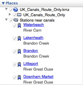
Now download the file "UK_Canals_Route_Only.kmz". Click on the three vertical dots on the right in the red header and select "Download kml".

Now import the file into your Google Earth sidebar:
(Menu: Open > and find where you saved your download)
Make sure it appears in your Layers sidebar and that it is ticked. Ticked layers are visible on the map, unticked layers are not. Untick anything you don't want to give more clarity leaving those you do want to see.
Now download the file "Stations_near_canals.kmz" in the same as you did for UK Canals Route, above.
Check that this appears in your Layers sidebar and tick it if necessary. Clicking on the little triangle to the left alternately opens the list up or closes it.
 For clarity you may decide to switch off certain features such as 3D buildings, weather etc.
The selection for rail and waterways, already built in to Google Earth, is hidden in the "More" section (Layers > Primary Database > More) so open the lists by clicking on the triangle and ensure that both Rail and Waterway are ticked.
This clip shows the town of Rugby with a red dot, the railway-station-near-a-canal with a chunky blue train, a primary waterway in blue, a secondary waterway in bright green and the surrounding countryside in dark green. If you search for Rugby or click on the Rugby label in your Google Earth Places list you should see this and more!

 Click on the chunky train icon to find out which canal is just a mile or so away and to get directions to and from that station.
 Click on the red railway sign
to find out more about the line the railway is on and its destinations.
Click on the red railway sign
to find out more about the line the railway is on and its destinations.
We have found ourselves wanting to moor up in a pleasant spot but having no easy way of getting home or even of visiting a nearby town (though Ely, see pic, is an exception).

I used Google Earth to trace the canals we planned to visit, noting railway stations up to a mile or so away from where we might moor up. We could then take the train home for a few days or visit nearby towns for a change of scene. There are 2552 stations on the Network Rail network and I've identified 290 near canals and rivers in England and Wales.
I think Google Earth is magic. There are umpteen "layers" that sit on top of the satellite images and I was thrilled to find there is a layer showing canals and rivers. So I decided to create my own layer of "railways near canals." I'll explain here how to use it, and I hope you find it useful. It's certainly a work in progress, as for many areas I have no knowledge of the ground, so I rely on you to update me and correct my data for the benefit of all.
How to set up.
Open Google Earth, or download it from here.
Now download the file "UK_Canals_Route_Only.kmz". Click on the three vertical dots on the right in the red header and select "Download kml".
Now import the file into your Google Earth sidebar:
(Menu: Open > and find where you saved your download)
Make sure it appears in your Layers sidebar and that it is ticked. Ticked layers are visible on the map, unticked layers are not. Untick anything you don't want to give more clarity leaving those you do want to see.
Now download the file "Stations_near_canals.kmz" in the same as you did for UK Canals Route, above.
Check that this appears in your Layers sidebar and tick it if necessary. Clicking on the little triangle to the left alternately opens the list up or closes it.

The selection for rail and waterways, already built in to Google Earth, is hidden in the "More" section (Layers > Primary Database > More) so open the lists by clicking on the triangle and ensure that both Rail and Waterway are ticked.
This clip shows the town of Rugby with a red dot, the railway-station-near-a-canal with a chunky blue train, a primary waterway in blue, a secondary waterway in bright green and the surrounding countryside in dark green. If you search for Rugby or click on the Rugby label in your Google Earth Places list you should see this and more!
Get Started. Now you have all the information you need to find railway stations near canals. Just browse the map using the tools at top right to zoom in and out and use your mouse to drag a route across the map.
Click on the chunky train icon to find out which canal is just a mile or so away and to get directions to and from that station.Click on the red railway sign
One other thing. The "Stations_near_canals.kmz" file can also be shown in a spreadsheet - stations_near_canals-data.xls . This shows just the unique name of the station and the nearby canal and you can search or arrange according to your needs. So you can now have a list of the nearby stations (usually within walking distance of a mile or so) for your chosen canal. Search for, or click on, the station name in Google Earth and you fly directly to it on the map, where more information can be found.
Caution: I can't guarantee the 100% accuracy of this data. Some of it is simple rule of thumb. What seems on the map to be just a hop and a skip away could mean a lengthy detour on the ground - and is that where you really want to moor up?
I'd encourage anyone who knows an area well to correct and amend to me, please, or in the comments box below. That way I can add to the list and we'll all find great mooring spots with railway stations nearby!
Postscript: There is now a Google Map site for canals and rivers. Open Canal Map doesn't specifically identify stations near canals but does show canals and rivers more clearly than the basic Google map. Try it at https://opencanalmap.uk/
Hi, Just found this from the link to my site - opencanalmap.uk - can I use your file in Open Canal Map? I wanted to add nearby stations.
ReplyDeleteCheers
Tom