Saturday, 28 May 2016

Leicester Line - Kilby Bridge to Welford

Back now through the heavy locks south of Kilby, though this time with a jolly little 20 foot cruiser who helped with the winding, while bobbing about trying to avoid being crushed by us in the locks.
We reach Foxton in good time and find there is one boat coming down and we are first going up. So after 20 minutes wait we attack the flight with relish and sprint to the top in just 35 minutes - which is about as fast as it can be done. A triumph celebrated by another pint and a meal at the Foxton Locks Inn as the sun goes down.
Next day is an easy trip back to Welford through delightful countryside in sunny conditions.
After a few small maintenance jobs - John having already tightened up a squeaking belt and now replaced the weed hatch seal we retire to The Wharf at Welford for another very well-priced lunch and the hour-long journey home.
Next we must repaint the stern deck which is flaking in places, paint non-slip powder on the gunwhales and replace the co-ax connectors on the TV which have rusted away. Always something to do on the cut ....


Kilby Bridge and Leicester

I've mentioned our arrival at Kilby Bridge and our meal at The Navigation in the previous blog entry  and now we took a day off to visit Leicester which neither of us had visited for many years.
It wouldn't be fair to diminish the huge success of the unexpectedly league-leading football club by saying that we were underwhelmed by Leicester city centre. After all, it was a day of dull weather and we were quite focused on what we wanted to see, but the people did seem very friendly and helped us with finding the right buses and pointed us (usually) in the right direction.
Regional TV is asking "Joan from Leicester" how she's going to vote in the referendum, but we are happy for her to tell us that we can easily walk 15 minutes from Kilby Bridge to Wigston and catch a bus into Leicester City Centre.

We found the famous car park where Richard III's body was found, visited his grave in the modest cathedral and found the visitors' centre well laid out and interesting. Richard's life is well explained and the discovery of his grave is described in detail.
From the excellent bus station (yes, really, great information and lots of space) we headed out to the National Space Centre (yes, in Leicester! - with cooperation from University of Leicester's Space Research Centre and land from a redundant pumping station).
With its child-friendly exhibits (a space toilet explained, interactive experiences, walk-through capsule etc) and impressive artefacts (a Soyuz capsule, space suits, actual rockets) the museum appeals to young and old, with hard questions about the origin and destination of the universe as well as "what would an alien look like".

The open design, determinedly avoiding a defined route through the six galleries areas plus planetarium and upper levels meant we felt a bit lost at times, but there was great variety for us and for the many children swarming around on school trips. Curiously the translucent 42 metre tower made apparently from plastic inflatables didn't allow for any viewing over the city. But then the view was less than impressive. Sorry, Leicester, but true.

Finally we visited the free Abbey Pumping Museum with its wonderful Victorian brass and mahogany pumps, created in the days when engineering had to be visually awe-inspiring even if it was just pushing effluent into pits. There are also rather random collections of plumbing, Meccano and a knitting machine. We enjoyed this and gather that their Events days with working steam pumps and narrow gauge railway are justifiably popular.


Leicester Arm - Foxton to Kilby Bridge

All is sunshine as we leave Foxton and head for Kilby Bridge.
This is delightful countryside, with boundless buttercup-laden fields, many with ridge and furrow, many with sheep and their well-fed lambs. Very relaxing.

But first there is 881 yards of Saddington Tunnel and its bat boxes, followed by Kibworth Top Lock, first of 12 locks in 10 miles to Kilby. Many of these locks are substantial, all widebeam, most with ground paddles as well as gate paddles and can be slow to fill and heavy to wind. Sharing with another boat is a very good idea ....
We break off for lunch and a stroll to The Church of St Luke, Newton Harcourt, unfortunately locked, but with a sturdy stone tower in an attractive setting.

A curious gravestone in the shape of the church commemorates a young boy
while another unusual modern shape reminds us of the estimable Lucy Charlton, who "made a difference to so many".
Shunning the village itself we continue towards Leicester with more energy sapping locks until we reached Kilby Bridge in good time. Picture below thanks to James Bell.
Here there is an unpretentious pub, The Navigation, offering mid week "Pauper's Supper" of three courses for £9.99. And very good it was, too, helped by an indefatigable waitress who deserved her tip.

The Leicester Arm - Welford to Foxton

Welford is on a short arm off the Leicester Arm of the Grand Union. We've often been up to Foxton Locks (see previous blogs) as it's just a three hour trip to the top lock with good moorings, interesting museum, attractive scene and the only lock is that at the end of the Welford Arm.
This time we thought we'd go further north and maybe venture into Leicester itself. However there are negative comments about the canals around Leicester, suggesting yobbish behaviour, broken windows, damaged locks - none of which we have any proof for, but tended to put us off. The general opinion was that Kilby Bridge was a useful and safe place to stay and by mooring there for two nights we could avoid the suburbs and more locks, while having easy access by bus to Leicester.
And so it proved. Foxton Locks was unfortunately busy with boats heading for the Crick Festival so we were queued at the summit, then again in the central pond while eight boats went up. It took just short of three hours to get to the bottom - including a challenging couple of minutes while Duncan conducted a complete circle in the central pond, whisked around by undercurrents. Or so he said.

Memo to users of Foxton Locks: the ten locks are deep but the paddles are easy to wind and the gates well balanced so the two flights are less exhausting than they first appear. However the locks are fed by side ponds which recycle the water and while economical on water use there is a danger for spectators (and there are always spectators at Foxton) of falling in (it has happened ...) and the inrush of water causes treacherous currents which can drive a boat in odd directions in the pound.

Anyway, we eventually moored just north of bridge 62 (see above) and enjoyed first a thirst-quenching pint at Bridge 61 then a pleasant meal at the Foxton Locks Inn. Tomorrow we would be in unfamiliar territory as we aimed to pass through 12 locks and a tunnel from Foxton to Kilby Bridge.


Thursday, 28 April 2016

The Grand Western Canal

Like the Somerset Coal Canal and the Bude Canal, here is another remote and land-locked West Country waterway, which was visited by John while staying in West Somerset, but which is off limits to Patience without the help of a low-loader.


The Grand Western Canal currently runs 11 miles through the beautiful mid-Devon countryside, from Tiverton in the west to Loudwells at its eastern end.  The Grand Western Canal was part of a planned 46 mile link from Topsham on the River Exe to Taunton, where it connected with the Bridgwater and Taunton Canal and, had it been completed through to Topsham, would have provided a link between the Bristol Channel and the English Channel. The Tiverton section opened in 1814 and for more than 100 years carried limestone from quarries at Holcombe to extensive lime kilns at Tiverton Basin, where quicklime was produced as a fertiliser.  However,  the section to Topsham was never built and by the mid 19th century the Tiverton to Taunton section was facing competition from Brunel's Great Western Railway.  It finally closed in 1924.

In recent years, the 11 mile lock-free section from Tiverton to Loudwells has been restored by Devon County Council as part of a country park. A few private narrow boats and day boats use it, as does a wide-beam horse drawn trip boat, the 'Tivertonian'.
Near Manley bridge there is a memorial to the two-man crew of an RAF Canberra bomber, which crashed into the canal on 21 November 1961 while on a training flight from Germany.

Tuesday, 26 April 2016

Still cold

We affirmed our belief that we are fair weather boaters by aborting a planned trip up the Leicester Arm due to bad weather. In intermittent heavy rain showers we did some basic maintenance, tanking up with water, disinfecting pipes and clearing air blocks while using the rain to scrub the rather grubby roof.
At a very good lunch at The Wharf (Welford) we agreed that the weather forecast (cold, sunny intervals broken by bands of rain, occasional light snow showers ...) wasn't attractive enough to entice us out, so we wrapped dear Patience up for another few weeks before we try to take her out again.
On an impulse we decided to go down to the museum at Stoke Bruerne (an hour by car - three days by boat!) and enjoyed the displays and the tea and cakes. A very friendly museum and a good spot near the Blisworth tunnel.
Last year we reached the Blisworth (north) end and opted not to continue to Stoke Bruerne as we were uncertain about moorings and turning. At 3,076 yards (2,813m) long it is the third-longest navigable canal tunnel on the UK canal network after Standedge Tunnel and Dudley Tunnel (and the ninth-longest canal tunnel in the world). On yesterday's inspection we need not have worried: there is extensive inline mooring and a good winding hole plus two pubs and two restaurants as well as the museum and café.
Here's the view of the lock - taken from the loading bay window of the old store that is now the museum. What appear to be two locks, one on either side of the central island is in fact one operating lock (on the left) and an old non-functioning one on the right.


 Hailstones start falling heavily as I write this. A good decision to call off our trip.

Wednesday, 10 February 2016

Railway Stations near Canals

Canals and rivers wend their way erratically across the country, not always reaching places that are convenient to access. Here is a solution - a map and a list of Railway Stations near canals.
We have found ourselves wanting to moor up in a pleasant spot but having no easy way of getting home or even of visiting a nearby town (though Ely, see pic, is an exception).

I used Google Earth to trace the canals we planned to visit, noting railway stations up to a mile or so away from where we might moor up. We could then take the train home for a few days or visit nearby towns for a change of scene. There are 2552 stations on the Network Rail network and I've identified 290 near canals and rivers in England and Wales.
I think Google Earth is magic. There are umpteen "layers" that sit on top of the satellite images and I was thrilled to find there is a layer showing canals and rivers. So I decided to create my own layer of "railways near canals." I'll explain here how to use it, and I hope you find it useful. It's certainly a work in progress, as for many areas I have no knowledge of the ground, so I rely on you to update me and correct my data for the benefit of all.
How to set up.
Open Google Earth, or download it from here.
Now download the file  "UK_Canals_Route_Only.kmz". Click on the three vertical dots on the right in the red header and select "Download kml".  


Now import the file into your Google Earth sidebar:
(Menu: Open > and find where you saved your download)
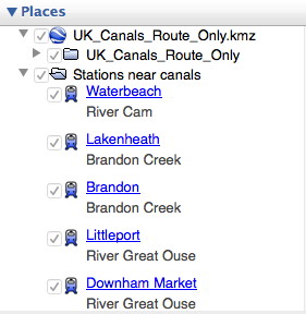


Make sure it appears in your Layers sidebar and that it is ticked. Ticked layers are visible on the map, unticked layers are not. Untick anything you don't want to give more clarity leaving those you do want to see.
Now download the file "Stations_near_canals.kmz" in the same as you did for UK Canals Route, above.
Check that this appears in your Layers sidebar and tick it if necessary. Clicking on the little triangle to the left alternately opens the list up or closes it.
 For clarity you may decide to switch off certain features such as 3D buildings, weather etc.
The selection for rail and waterways, already built in to Google Earth, is hidden in the "More" section (Layers > Primary Database > More) so open the lists by clicking on the triangle and ensure that both Rail and Waterway are ticked.
This clip shows the town of Rugby with a red dot, the railway-station-near-a-canal with a chunky blue train, a primary waterway in blue, a secondary waterway in bright green and the surrounding countryside in dark green. If you search for Rugby or click on the Rugby label in your Google Earth Places list you should see this and more!

Get Started. Now you have all the information you need to find railway stations near canals. Just browse the map using the tools at top right to zoom in and out and use your mouse to drag a route across the map.

Click on the chunky train icon to find out which canal is just a mile or so away and to get directions to and from that station.
Click on the red railway sign
to find out more about the line the railway is on and its destinations.

One other thing. The "Stations_near_canals.kmz" file can also be shown in a spreadsheet - stations_near_canals-data.xls . This shows just the unique name of the station and the nearby canal and you can search or arrange according to your needs. So you can now have a list of the nearby stations (usually within walking distance of a mile or so) for your chosen canal. Search for, or click on, the station name in Google Earth and you fly directly to it on the map, where more information can be found. 

Caution: I can't guarantee the 100% accuracy of this data. Some of it is simple rule of thumb. What seems on the map to be just a hop and a skip away could mean a lengthy detour on the ground - and is that where you really want to moor up? 
I'd encourage anyone who knows an area well to correct and amend to me, please, or in the comments box below. That way I can add to the list and we'll all find great mooring spots with railway stations nearby!

Postscript:  There is  now a Google Map site for canals and rivers. Open Canal Map doesn't specifically identify stations near canals but does show canals and rivers more clearly than the basic Google map. Try it at https://opencanalmap.uk/